

On March 22nd, a massive landslide buried a town in the state of Washington. It is the most deadly landslide within the United States in a decade, and we knew it could happen. Living in the path of impending catastrophe is a choice we all make daily, but that doesn’t make it easy.
The Steelhead Landslide
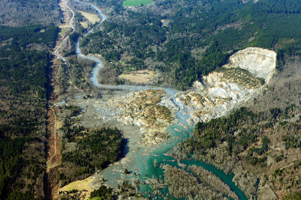
The Steelhead Landslide (also called the Hazel Landslide or the Oso Mudslide) is located about 90 km northeast of Seattle, in the community of Oso, Washington.
The landslide is composed of glacial sediments, a mix of sands, silts, and rocks that turned into mud in the recent heavy rains. The landslide ripped up trees, entrained saturated soils and potentially even mixed river water into its mass, increasing volume and mobility as it ran downhill.
By looking at satellite imagery, the failure area is roughly 450 meters wide and up to 500 m long. Judging from where the river cut through the debris, the landslide might be 10 m thick. As a very rough estimate, that puts the volume of this landslide at 2 million cubic meters, into the territory of a catastrophically large landslide.
From the head scarp of the failure area to the distant toe of the deposit, the runout distance is somewhere over 1.7 km long. The landslide split at the river, spreading to around 1.3 km wide. The landslide briefly dammed the North Fork Stillaguamish River. A USGS stream gague about 20 km downstream measures the river level in near-realtime. The landslide occurred around 11 am on Saturday; the gage reported an abruptly drop in water level at 1:30 pm. The discharge decreased by about 34 cubic meters per second, with all that water building up behind the dam.
The dam held for about 30 hours before the stream eroded a new path through the deposit. At its peak, the drop in discharge suggests the dam was holding back over 3 million cubic meters of water; the USGS described the upstream pond as up to 10 meters deep. Fortunately, it looks like the dam is releasing the trapped water slowly, carrying debris and sediment downstream but not failing catastrophically with an outburst flood. A flash flood warning will remain in effect for downstream communities until the barrier lake finishes draining.

